

Your own layers
FeatureLayer is what Buildings and Roads are made of: give it a source of features and a build that draws a terrain tile; it loads the source’s tiles (shared, cancelled when unused), draws every tile when its features arrive, and again when the heights it read change. What you draw goes into named parts — one object per part and tile, each with its material — and what you wrap in ctx.feature() can be picked and highlighted.
import { Color, Group } from 'three'import { FeatureLayer } from 'three-map-terrain'
interface Tree {  id: number  position: [lon: number, lat: number]  height: number}
const trees = map.addLayer(  new FeatureLayer<Tree>({    name: 'trees',    source: {      minZoom: 15,      maxZoom: 15,      attribution: '© My city',      load: async ({ z, x, y, signal }) =>        (await fetch(`/trees/${z}/${x}/${y}.json`, { signal })).json()    },    build(ctx) {      const [minX, minY, maxX, maxY] = ctx.rect      for (const tree of ctx.allFeatures) {        const [x, y] = ctx.toLocal(tree.position)        if (x < minX || x >= maxX || y < minY || y >= maxY) continue // another tile's        ctx.feature(tree, () => {          const model = treeModel.clone() // any Object3D, in the tile's coordinates          model.position.set(x, y, ctx.groundAt(x, y))          model.scale.setScalar(tree.height * ctx.zScale)          ctx.add(model)        })      }    }  }))
trees.pick(raycaster)?.feature // the Tree under the pointer
The summits of the Bernese Alps as a layer: pins, copies of one geometry (ctx.instances), standing on the rendered surface, picked and highlighted:
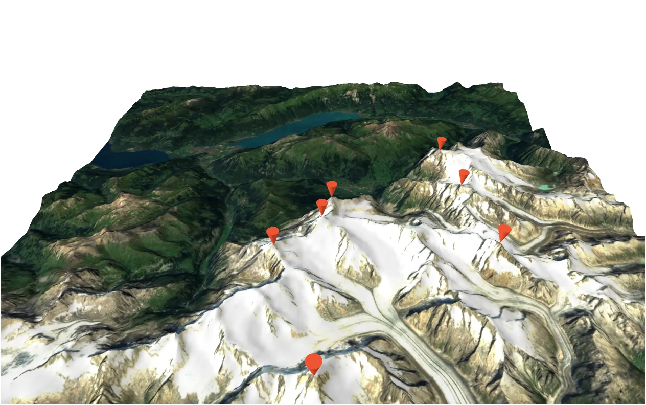
import { ConeGeometry, Float32BufferAttribute, Matrix4 } from 'three'import { FeatureLayer, Map } from 'three-map-terrain'
import type { Demo } from './stage'
interface Summit {  id: number  name: string  position: [lon: number, lat: number]}
// your data: here a list, in a real app tiles of a server or a databaseconst SUMMITS: Summit[] = [  { id: 1, name: 'Eiger, 3967 m', position: [8.0053, 46.5776] },  { id: 2, name: 'Mönch, 4107 m', position: [7.9973, 46.5585] },  { id: 3, name: 'Jungfrau, 4158 m', position: [7.9625, 46.5367] },  { id: 4, name: 'Schreckhorn, 4078 m', position: [8.1181, 46.5897] },  { id: 5, name: 'Finsteraarhorn, 4274 m', position: [8.1263, 46.5373] },  { id: 6, name: 'Aletschhorn, 4193 m', position: [7.9932, 46.4652] },  { id: 7, name: 'Wetterhorn, 3692 m', position: [8.1153, 46.6372] }]
// a pin standing on its tip, 3 high; white vertex colors: the part's// material gives the colorconst pin = new ConeGeometry(1, 3, 16)  .rotateX(-Math.PI / 2)  .translate(0, 0, 1.5)const vertices = pin.getAttribute('position').countpin.setAttribute(  'color',  new Float32BufferAttribute(new Float32Array(vertices * 3).fill(1), 3))
// A layer of your own: its features, drawn on every terrain tile they are// in, picked and highlightedconst summits: Demo = ({ scene, camera, onClick, status }) => {  const map = new Map({    source: { api: 'eox' },    location: { lat: 46.57634, lon: 7.9904 }  })  const layer = map.addLayer(    new FeatureLayer<Summit>({      name: 'summits',      source: { minZoom: 0, maxZoom: 11, load: () => Promise.resolve(SUMMITS) },      material: { color: '#ff5a36' },      build(ctx) {        const [minX, minY, maxX, maxY] = ctx.rect        const size = 350 * ctx.unitsPerMeter        for (const summit of ctx.allFeatures) {          const [x, y] = ctx.toLocal(summit.position)          if (x < minX || x >= maxX || y < minY || y >= maxY) continue // another tile's          ctx.feature(summit, () => {            const matrix = new Matrix4()              .makeScale(size, size, size)              .setPosition(x, y, ctx.groundAt(x, y))            ctx.instances('pins', pin).add(matrix)          })        }      }    })  )  scene.add(map.terrain)  void map.init()  camera.position.set(0, -1200, 900)
  status('Click a pin')  onClick((raycaster) => {    const hit = layer.pick(raycaster)    layer.highlight(hit?.feature)    status(hit ? hit.feature.name : 'Click a pin')  })  return map}
export default summits
TileContext
Section titled “TileContext”The ctx has the tile’s features and the primitives that put geometry on the terrain, in the tile’s local coordinates (scene units, x east, y north):
| Primitive | Draws |
|---|---|
drapePolygon(part, rings, { color, clip }) |
A polygon with holes lying on the terrain: water, parks, fields — cut along the terrain’s triangles, lit like it |
drapeLine(part, line, width, { color }) |
A ribbon lying on the terrain, with round caps; UVs across and along in meters |
drapePath(part, line, { color }) |
A line lying on the terrain (lines are built only if their part’s material is visible) |
extrude(polygons, bottom, top, style) |
Walls, a roof and a floor (floor), and their edges — into the parts walls, roofs, floors, edges or the parts you name; with ground the edges begin where the walls leave the ground ('outline': the bottom outline along it) |
face(part, points, { color, normal, uv }) |
Any planar convex polygon [x, y, z, …], turned to face normal |
segment(part, a, b, color) |
A line from [x, y, z] to [x, y, z] |
instances(part, geometry).add(matrix, color?) |
Copies of a shared geometry — trees, lamps — one InstancedMesh per part and tile, each copy picked as its feature, outlined in wireframe |
add(object) |
Any object — a model, an InstancedMesh; picked as the feature being drawn |
And what they are made of: toLocal([lon, lat]), groundAt(x, y) (the rendered surface, also in loaded neighbours), surfaceAt(x, y) (height and normal, undefined where not loaded), unitsPerMeter, zScale, rect (the tile), sources (the features by source tile, with its rect), planarUv(x, y), visible(part, kind?) (whether a part’s material shows: skip drawing what it hides — the tile is drawn again once it shows), and the raw surface(part) / lines(part) builders. Heights read through ctx are tracked: the tile is drawn again when they change.
The built-in layers’ geometry
Section titled “The built-in layers’ geometry”The built-in layers take a build too, which receives their own drawing as draw(features?) — replace the geometry of some features, keep it for the others:
new Buildings({ source: { api: 'openfreemap' }, build(ctx, draw) { // your models for some buildings, the extrusion for the rest draw(ctx.allFeatures.filter((building) => !models.has(building.id))) for (const building of ctx.allFeatures) { const model = models.get(building.id) if (!model) continue ctx.feature(building, () => { const [x, y] = ctx.toLocal(anchorOf(building)) model.position.set(x, y, ctx.groundAt(x, y)) ctx.add(model) }) } }})A layer class
Section titled “A layer class”Subclass FeatureLayer for a reusable layer: override draw(ctx, features) (and select() to decide which tile draws a feature crossing tiles, partColor() / createMaterial() for its look — colors in the materials, so that a new look only changes them — sourceLoaded() / prepare() for what spans tiles — Roads joins its bridges there — and canDraw(tile) to wait for other layers, as Vegetation waits for avoid). FeatureLayer is new in 3.0: its API may still grow.
MapLayer
Section titled “MapLayer”Underneath is MapLayer, the interface the map talks to; implement it for anything that is not tile features — every method is optional:
map.addLayer({ attribution: '© My data', // listed in map.attributions attach(map) {}, // added: map.terrain is there to add objects to tileLoaded(tile) {}, // a tile is in the scene: tile.heightAt(u, v), tile.mesh.position tileChanged(tile) {}, // its heights changed: a neighbour loaded and the seams were stitched tileRemoved(tile) {}, // free what you made for it materialChanged(map) {}, // map.setMaterial(): follow map.materialOptions whenReady: async () => {}, // map.whenReady() and map.export() wait for it detach(map) {} // map.removeLayer()})