

Getting started
Install
Section titled “Install”npm install three three-map-terrain# or: yarn add three three-map-terrain · pnpm add three three-map-terrainRequires three ≥ 0.152.
Quick start
Section titled “Quick start”import { PerspectiveCamera, Scene, WebGLRenderer } from 'three'import { MapControls } from 'three/addons/controls/MapControls.js'import { Map } from 'three-map-terrain'
const scene = new Scene()const camera = new PerspectiveCamera(60, innerWidth / innerHeight, 1, 1e6)camera.up.set(0, 0, 1) // the terrain lies in the XY plane, Z is upcamera.position.set(0, -1200, 900)
const renderer = new WebGLRenderer({ antialias: true })renderer.setSize(innerWidth, innerHeight)document.body.append(renderer.domElement)const controls = new MapControls(camera, renderer.domElement)
const map = new Map({ source: { api: 'eox' }, // Sentinel-2 imagery location: { lat: 46.57634, lon: 7.9904 } // Bernese Alps})scene.add(map.terrain)await map.init() // geometry is ready; textures keep streaming in
renderer.setAnimationLoop(() => { controls.update() renderer.render(scene, camera)})Built-in materials react to lights: add an AmbientLight and a DirectionalLight, or pass material: { lights: false }.
A Map is a grid of tiles — nTiles × nTiles (3 by default) at zoom (11) around location, or any rectangle of tiles as grid — and map.terrain is a Group with a mesh per tile. Its options set the size, detail and vertical scale.
Put things on the map
Section titled “Put things on the map”// on the rendered surface, wherever the terrain isconst { x, y, z } = await map.getTerrainPosition({ lat: 46.6242, lon: 8.0414 })marker.position.set(x, y, z)
// every frame, for moving objects (undefined until that tile has loaded)const p = map.getTerrainPositionSync({ lat, lon })if (p) vehicle.position.set(p.x, p.y, p.z)
// at an altitude in meters, e.g. an aircraftconst { x, y, z } = map.getPosition({ lat, lon, alt: 3000 })
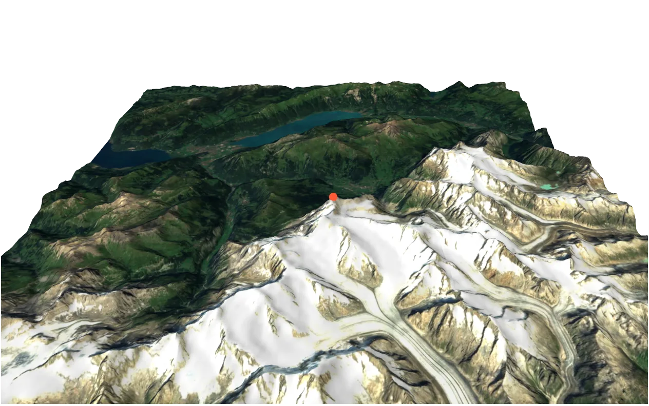
// the geolocation under the pointerraycaster.setFromCamera(pointer, camera)const hit = map.pick(raycaster) // { lat, lon, alt, point } | undefinedPositions are in map.terrain coordinates: X east, Y north, Z up. The quick start’s map with a marker on the Eiger and the geolocation of a click — the demos on these pages leave out the scene, the camera and the renderer, as above:
import { Mesh, MeshBasicMaterial, SphereGeometry } from 'three'import { Map } from 'three-map-terrain'
import type { Demo } from './stage'
// The Bernese Alps on Sentinel-2 imagery, a marker on the Eiger, and the// geolocation under the pointerconst alps: Demo = ({ scene, camera, onClick, status }) => {  const map = new Map({    source: { api: 'eox' },    location: { lat: 46.57634, lon: 7.9904 }  })  scene.add(map.terrain)  void map.init() // geometry first; textures keep streaming in  camera.position.set(0, -1200, 900)
  // on the rendered surface: the tile is loaded first  const marker = new Mesh(    new SphereGeometry(12),    new MeshBasicMaterial({ color: '#ff5a36' })  )  map.terrain.add(marker) // in map.terrain's coordinates  void map.getTerrainPosition({ lat: 46.5776, lon: 8.0053 }).then((p) => {    marker.position.set(p.x, p.y, p.z)  })
  status('Click the terrain')  onClick((raycaster) => {    const hit = map.pick(raycaster)    if (hit) {      const { lat, lon, alt } = hit      status(`${lat.toFixed(5)}, ${lon.toFixed(5)} · ${Math.round(alt)} m`)    }  })  return map}
export default alps
React Three Fiber
Section titled “React Three Fiber”import { MapControls } from '@react-three/drei'import { Canvas } from '@react-three/fiber'import { useEffect, useMemo } from 'react'import { Map } from 'three-map-terrain'
export function Terrain() { const map = useMemo( () => new Map({ source: { api: 'eox' }, location: { lat: 46.57634, lon: 7.9904 } }), [] )
useEffect(() => { void map.init() return () => map.clean() // aborts requests, frees GPU memory }, [map])
return <primitive object={map.terrain} />}
export default function App() { return ( <Canvas camera={{ up: [0, 0, 1], position: [0, -1200, 900], far: 1e6 }}> <ambientLight intensity={1.5} /> <directionalLight position={[-1e4, 1e4, 1e4]} intensity={2.5} /> <Terrain /> <MapControls /> </Canvas> )}clean() in the effect’s cleanup makes it safe in StrictMode, which mounts twice in development. Pointer events already carry the hit: map.getLocation(map.terrain.worldToLocal(event.point.clone())).